Exploring For the Future
Type of resources
Keywords
Publication year
Topics
-
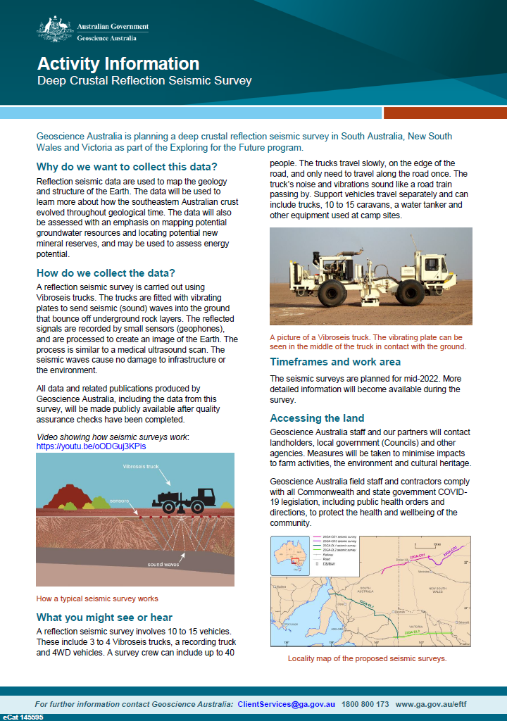
Geoscience Australia is planning a deep crustal reflection seismic survey in South Australia, New South Wales and Victoria as part of the Exploring for the Future program
-
The onshore Canning Basin in Western Australia is the focus of a regional hydrocarbon prospectivity assessment being undertaken by the Exploring for the Future (EFTF) program; an Australian Government initiative dedicated to increasing investment in resource exploration in northern Australia. The four-year program led by Geoscience Australia focusses on the acquisition of new data and information about the potential mineral, energy and groundwater resources concealed beneath the surface in northern Australia and parts of South Australia. As part of this program, significant work has been carried out to deliver new pre-competitive data including new seismic acquisition, drilling of a stratigraphic well and the geochemical analysis of geological samples recovered from exploration wells. As part of this comprehensive analytical program, TOC and Rock-Eval pyrolysis analyses were undertaken by Geoscience Australia on selected rock samples from eight wells of the Canning Basin to establish their hydrocarbon-generating potential and thermal maturity. These samples were selected to infill gaps in the existing open file data with a particular focus on the Lower Ordovician Nambeet Formation for comparison with samples from the Waukarlycarly 1 well.
-
The onshore Canning Basin in Western Australia is the focus of a regional hydrocarbon prospectivity assessment being undertaken by the Exploring for the Future (EFTF) program; an Australian Government initiative dedicated to increasing investment in resource exploration in northern Australia. The four-year program led by Geoscience Australia focusses on the acquisition of new data and information about the potential mineral, energy and groundwater resources concealed beneath the surface in northern Australia and parts of South Australia. As part of this program, significant work has been carried out to deliver new pre-competitive data including new seismic acquisition, drilling of a stratigraphic well and the geochemical analysis of geological samples recovered from exploration wells. A regional, 872 km long 2D seismic line (18GA-KB1) acquired in 2018 by Geoscience Australia (GA) and the Geological Survey of Western Australia (GSWA), images the Kidson Sub-basin of the Canning Basin. In order to provide a test of geological interpretations made from the Kidson seismic survey, a deep stratigraphic well, Waukarlycarly 1, was drilled in 2019 in partnership between Geoscience Australia (GA) and the Geological Survey of Western Australia (GSWA) in the South West Canning Basin. The Waukarlycarly 1 stratigraphic well was drilled in the Waukarlycarly Embayment, 67 km west of Telfer and provides stratigraphic control for the geology imaged by the Kidson seismic line (Figure 1). The well was drilled to a total drillers depth (TD) of 2680.53 mRT and penetrated a thin Cenozoic cover overlying a Permo-Carboniferous fluvial clastic succession that includes glacial diamictite. These siliciclastics unconformably overlie an extremely thick (>1730 m) interpreted Devonian to Ordovician succession before terminating in low-grade metasediments of presumed Neoproterozoic age. Log characterisation, core analysis, geochronology, petrographic and palaeontological studies have been carried out to characterise the lithology, age and depositional environment of these sediments. As part of this comprehensive analytical program, TOC and Rock-Eval pyrolysis analyses were undertaken by Geoscience Australia on selected rock samples to establish their hydrocarbon-generating potential and thermal maturity.
-
<p>The Solid Geology of the North Australian Craton 1:1M scale dataset 1st edition (2020) is a seamless chronostratigraphic solid geology dataset of the North Australian Craton that covers north of Western Australia, Northern Territory and north-west Queensland. The data maps stratigraphic units concealed under cover by effectively removing the overlying cover (Liu et al., 2015). This dataset comprises five chronostratigraphic time slices, namely: Cenozoic, Mesozoic, Paleozoic, Neoproterozoic, and Pre-Neoproterozoic. As an example, the Mesozoic time slice (or layer) shows Mesozoic age geology that would be present if all Cenozoic units were removed. The Pre-Neoproterozoic time slice shows what would be visible if all Neoproterozoic, Paleozoic, Mesozoic, and Cenozoic units were removed. <p>Geological units are represented as polygon and line geometries and, are attributed with information regarding stratigraphic nomenclature and hierarchy, age, lithology, and primary data source. The datasets also contains geological contacts, structural features, such as faults and shears, and miscellaneous supporting lines like crater impacts or structural grain within stratigraphic units. <p>This is the second staged release of Geoscience Australia's national time based solid geology mapping program commenced under the Federal Government’s Exploring for the Future program. The Cenozoic time slice layer was extracted from Raymond, O.L., Liu, S., Gallagher, R., Highet, L.M., Zhang, W., 2012. Surface Geology of Australia, 1:1 000 000 scale, 2012 edition [Digital Dataset]. Geoscience Australia, Commonwealth of Australia, Canberra. http://www.ga.gov.au and retains the data schema of that dataset. For this layer’s metadata, refer to https://pid.geoscience.gov.au/dataset/ga/74619 <p>NOTE: Specialised Geographic Information System (GIS) software is required to view this data.